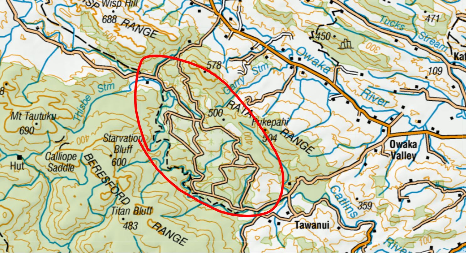
Looking to poke around in the Catlins area. There are a bunch of roads like Puketawa, Shaw, Rocky Knob, and Catlins roads southwest of the Rata range, east of the Catlins river track, that look like they snake through pine forestry. Does anyone know if these roads are private/locked?
Is there an easy way online to find out if roads are open or not? Ive been in situations where hunting plans were foiled because when I attempted to drive through an area to access DOC land, there was a big locked barrier in the way.

Welcome guest, is this your first visit? Create Account now to join.
Welcome to the NZ Hunting and Shooting Forums.
Search Forums
User Tag List
+ Reply to Thread
Results 1 to 12 of 12
 17Likes
Thread: Anyone know if these Rata Range (Catlins) roads are locked?
-
01-05-2022, 03:36 AM #1
Anyone know if these Rata Range (Catlins) roads are locked?
-
-
01-05-2022, 07:54 AM #2Member

- Join Date
- Oct 2019
- Location
- Owaka
- Posts
- 267
I feel like I heard they had recently been gated.
-
01-05-2022, 02:35 PM #3
Shame if true, though sometimes ive called forestry numbers on gates for access permission, they obliged (yay) on quiet days with no trucks. Other times with some companies they close those gates permanently to recreational users of the forest.
If I end up checking that area out I will report back with the status. Depends on if I get a spot in one of the restricted areas.
-
01-05-2022, 03:30 PM #4Member

- Join Date
- Oct 2012
- Location
- Invercargill
- Posts
- 1,925
If Rayonier itís a whole new experience. Basically individuals are out. Clubs are in.
Some of the other companies are very accomodating
-
01-05-2022, 03:35 PM #5
-
01-05-2022, 03:38 PM #6
Anyone know if these Rata Range (Catlins) roads are locked?
Access roads go thru forestry blocks. While harvesting in there they have the gates locked for safety reasons. So in short, yep theyíre locked at the moment and have been for a couple of years. Forests are owned managed by Rayonier Matariki Forests in Invers if you want to talk to them.
Sent from my iPhone using TapatalkI'm drawn to the mountains and the bush, it's where life is clear, where the world makes the most sense.
-
01-05-2022, 03:47 PM #7
Thanks for the info. I was trying to find out which company owns the forestry there so I can at least ask them if I can walk by foot on the side of the roads there, but if there is going to be a lot of truck activity i will likely go elsewhere.
-
01-05-2022, 03:47 PM #8
Anyone know if these Rata Range (Catlins) roads are locked?
The better hunting around there is the fringes, which are all pretty accessible on foot. Only bush during the roar period. I wouldnít bother going deep into that country unless itís during the roar.
Get on the Catlins River Walk and cross anywhere up into the sunny faces over the river and youíll find deer.
PM me with any specific areas you want to look at down that way and Iíll probably be able to help.
Sent from my iPhone using TapatalkI'm drawn to the mountains and the bush, it's where life is clear, where the world makes the most sense.
-
01-05-2022, 04:22 PM #9
I know manager at Wisp Hill if you wanted me to ask him what the go is up there. Won’t be there much longer either though as that place is going into trees also…. Bloody criminal.
Flappy Disc Customs Bespoke Hunting Rifles
-
01-05-2022, 06:06 PM #10Member

- Join Date
- Mar 2022
- Location
- Catlins
- Posts
- 537
There was plenty of fresh sign at Willis Stream, about an hour easy walk down from the top car park. Nice place to camp and there is a forestry
track to it if you manage to gain access. There were 4wheeler marks in the grass and a freshly setup possum trap.
I was there a couple of months ago just for day walk with my wife. Very pleasant and I think you’ll do okay. Easy enough to explore for the first time.ďAge is a very high price to pay for maturityĒ
-
01-05-2022, 06:27 PM #11
-
01-05-2022, 08:21 PM #12
Anyone know if these Rata Range (Catlins) roads are locked?
That is a small restricted block, itís steep and pretty hard hunting, but worth a look.
Wisp Hill Station mainly boundaries all the Catlins Rainforest Park from Mt Tautuku area westwards. From Catlins River walk past Thisbe Stream and west to Wairepo Creek.
There are a couple of access points off Cairn Road. ROWís thru station to Public land go thru swamps, so you canít follow them without trespassing.
Access to public land thru the station will improve in the future though which will be good.
Sent from my iPhone using TapatalkI'm drawn to the mountains and the bush, it's where life is clear, where the world makes the most sense.
Similar Threads
-
Locked out
By Ranger 888 in forum Questions, Comments, Suggestions, Testing.Replies: 2Last Post: 17-07-2019, 10:38 PM -
3 legged GSP locked up for theft
By RCGSP in forum Hunting DogsReplies: 8Last Post: 16-01-2013, 10:47 PM -
3 legged GSP locked up for theft
By RCGSP in forum DogsReplies: 8Last Post: 16-01-2013, 10:47 PM
Tags for this Thread
Welcome to NZ Hunting and Shooting Forums! We see you're new here, or arn't logged in. Create an account, and Login for full access including our FREE BUY and SELL section Register NOW!!


 LinkBack URL
 About LinkBacks


 Reply With Quote


Bookmarks