

 50Likes
 LinkBack URL
 About LinkBacks
Legal access and land ownership is shown on the walking access NZ web site
set the base map to topo
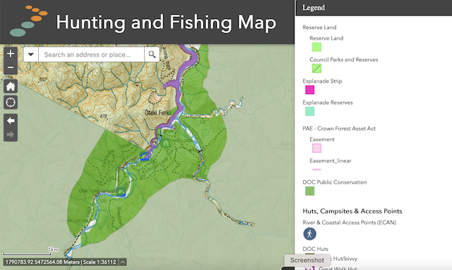
Here is Otaki Forks
"clear" areas where you can see the contours are private land
One of these squiggly lines is a farm/logging track and the other two are river beds that would have had farmable flats. In most places river beds are public land but not quite all.
magenta is public roads (not all formed, some just legal "paper roads")
Light green is Reserve. Check if your DoC hunting permit covers it. Sometimes you can get a permit.
The dull green is standard Doc land, generally covered by a hunting permit.
Welcome guest, is this your first visit? Create Account now to join.
Welcome to the NZ Hunting and Shooting Forums.
Search Forums


User Tag List
+ Reply to Thread
Results 1 to 15 of 44
Hybrid View
-
30-12-2021, 10:32 PM #1Member

- Join Date
- Mar 2012
- Location
- Waikato
- Posts
- 2,165
-
31-12-2021, 02:45 PM #2Member
- Join Date
- Dec 2021
- Location
- NZ
- Posts
- 17
Thank you very much. Its quite similar to the DOC maps but you can overlay everything which now means I do not have to go back and forth between the DOC maps and Google earth. So lets take Raukumara, if I stick to the public/doc identified on this mapping system, I will avoid pissing anybody off by straying across Iwi land or private blocks? Originally Posted by Bagheera

Still having a go with the tool to see how I can use it. Do a lot of people use it when out and about? I sold my Garmin handheld. Im wondering what the best map would be to use via GPS on your phone? In saying that the better half has tough tablets for their GIS work so I could "borrow" one of those. I will always carry a printed map and compass however.


 Reply With Quote
Similar Threads
-
bush stalking for dummies
By Micky Duck in forum HuntingReplies: 37Last Post: 23-09-2021, 01:39 PM -
bush stalking pigs
By allister in forum HuntingReplies: 22Last Post: 25-08-2021, 03:14 PM -
Bush stalking the first deer
By Dominator in forum HuntingReplies: 18Last Post: 30-11-2020, 08:21 AM -
Bush stalking - not my best skill
By tikka 7/08 in forum HuntingReplies: 43Last Post: 05-11-2012, 05:32 PM -
Silver Peaks/Careys stream or Pigeon Bush
By Alpinehunter0 in forum HuntingReplies: 0Last Post: 20-10-2012, 05:26 PM
Tags for this Thread
 Posting Permissions
- You may not post new threads
- You may not post replies
- You may not post attachments
- You may not edit your posts
Welcome to NZ Hunting and Shooting Forums! We see you're new here, or arn't logged in. Create an account, and Login for full access including our FREE BUY and SELL section Register NOW!!
All times are GMT +13. The time now is 05:58 PM.

Bookmarks