Welcome guest, is this your first visit? Create Account now to join.
Welcome to the NZ Hunting and Shooting Forums.
Search Forums
User Tag List
+ Reply to Thread
Results 331 to 345 of 592
Thread: Kaimanawa Forest Park
-
02-08-2022, 08:04 PM #331Experience. What you get just after you needed it.
-
-
02-08-2022, 08:20 PM #332Member

- Join Date
- Jun 2014
- Location
- CNI
- Posts
- 5,985
Yes but what is it actually.
It allows public vehicular access into the Kaimanawa Forest Park for many and varied users.
Why not the four accesses off Desert road?
Just saying.Summer grass
Of stalwart warriors splendid dreams
the aftermath.
Matsuo Basho.
-
02-08-2022, 08:50 PM #333Member

- Join Date
- Apr 2012
- Location
- Kingcountry
- Posts
- 5,052
Bit like Waitaramoa Road into Pureora North Block, no one wants to own it when it requires work. DOC will come to the party for a 1080 drop or other poison operation, logging companies if pines are being carted, otherwise ownership is denied by all including the 2 district councils.
-
02-08-2022, 09:05 PM #334Member

- Join Date
- Jun 2014
- Location
- CNI
- Posts
- 5,985
There must be many examples throughout NZ. Access is not denied.
Clements road was pioneered by a man of that name whose men cut and split red beech for posts and battens. I can recall when the gear and original huts were in place and the bridges were simple double planks with a big gap in the centre. The "road" is now an important public and tourist asset. (As is View road.) They along with the desert road accesses are of economic benifit to the district and to NZ bringing in dollars including tourist dollars. These accesses should not be allowed to become private enterprise money pots for a few. They have been and should remain free to the publics use.Summer grass
Of stalwart warriors splendid dreams
the aftermath.
Matsuo Basho.
-
03-08-2022, 07:47 AM #335
As someone who has a great appreciation of freedom/liberty/access and the law, this will be a very interesting outcome that I will be following closely.
However, it's not difficult to see why the local iwi are upset with the destruction of the whenua at the road end. A quick search of waipakahihi road 4x4 on YouTube shows vehicles travelling in the river, driving close to whio, dogs running free, chainsaw use and tree felling.
Sure I didn't see a "hunter" amongst them it does however reflect on all waipakahihi road users.
https://youtu.be/ZlVhJGtj1M0
@2min 30secsLast edited by stumpys; 03-08-2022 at 07:53 AM.
-
03-08-2022, 09:47 AM #336Member

- Join Date
- May 2017
- Location
- Tauranga
- Posts
- 745
That maybe so @stumpys and had the gate had gone in 5 - 10 years ago, at the expense of the landowner, for the reason you state, I might be included to agree, but the timing of this tells us all we need to know
-
03-08-2022, 09:52 AM #337
Im with Stumpy,the writing was on the wall it was getting pretty ugly.They still might let walking access.
-
03-08-2022, 10:57 AM #338Member

- Join Date
- Jun 2014
- Location
- CNI
- Posts
- 5,985
The rule breaking looked to me to be within the park rather than on private land. A sign placed on the park boundary against taking vehicles across at the river as happens elsewhere should suffice.
Summer grass
Of stalwart warriors splendid dreams
the aftermath.
Matsuo Basho.
-
03-08-2022, 11:01 AM #339
Absolutely, the "conflict of interest “ here between iwi and helisika stinks. Paying for a concession, Lock out the public and then day "we can fly you!" Is beyond reproach. I hope access remains and that people clean up their act, comprehend kaitiakitanga and respect the great asset that we should all have.
Was BINGO the name of the farmer or the dog?
-
03-08-2022, 12:35 PM #340Member

- Join Date
- Feb 2018
- Location
- North Island
- Posts
- 147
Bit late to this investigation but thought I'd post the relevant info for people to see. I'm a cadastral surveyor so have access to plans etc, have been involved in road taking and stopping by local government act in the past.
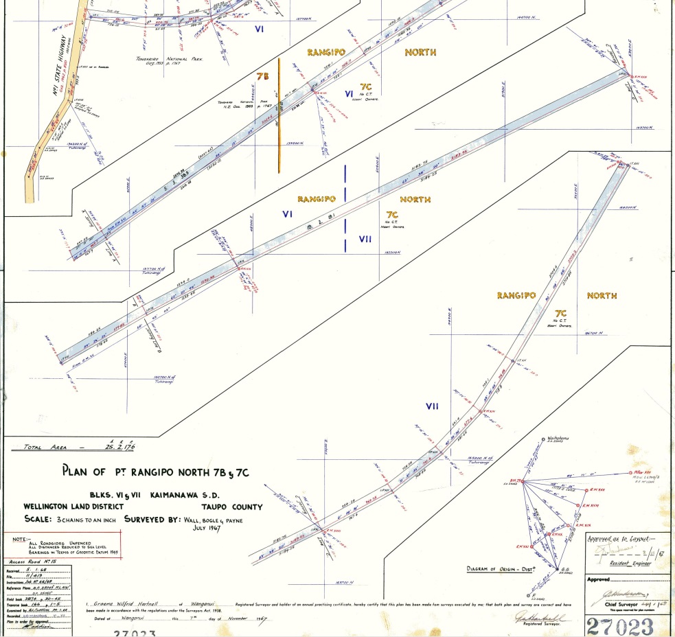
So a quick search of Waipakihi Road shows it is covered by two parcels, Part Rangipo North 7B Block and Part Rangipo North 7C Block. Both these parcels were created by survey SO 27023 1967 shown below....

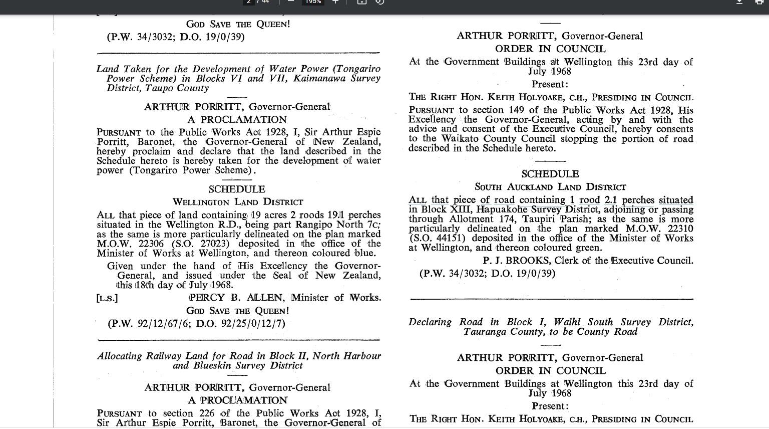
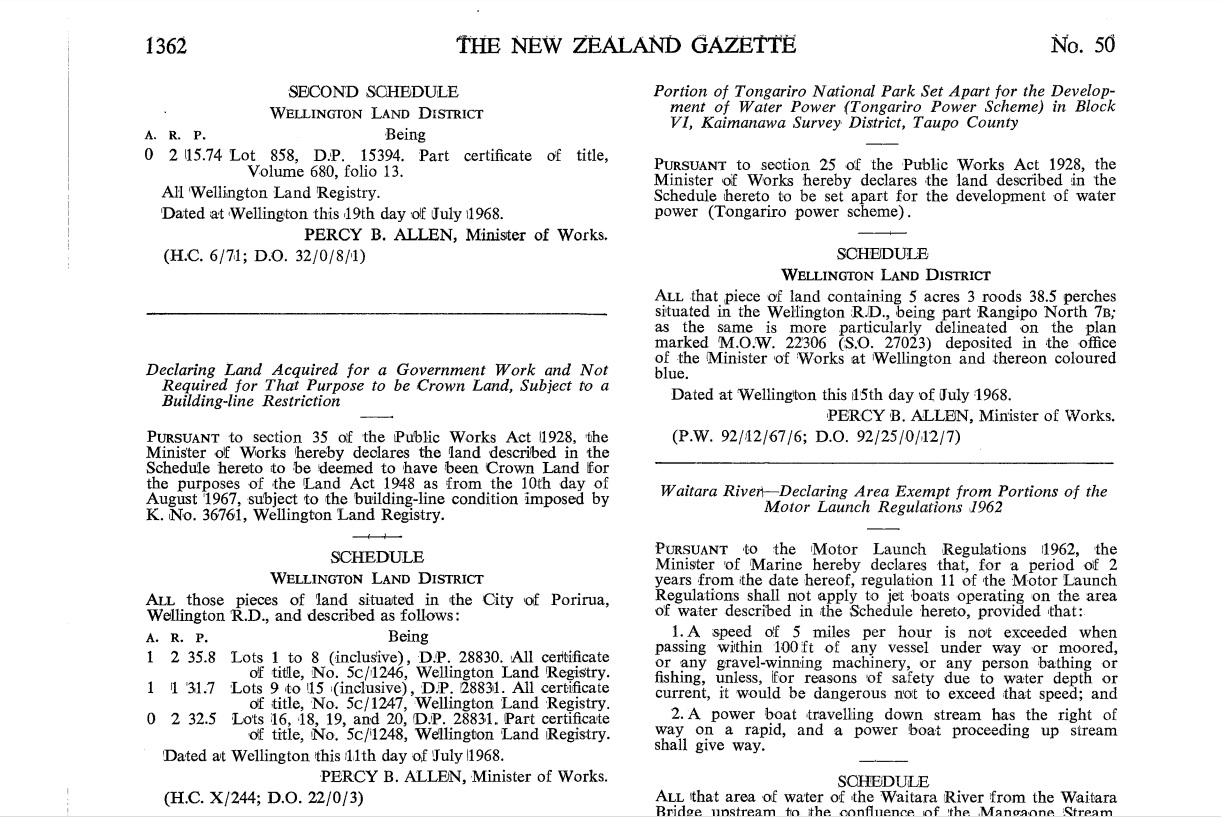
The two parcels have a gazette reference to them - Gazette 1968 p1344 and p1362. The gazette is Government newspaper used for public notification/record to legalise processes and actions under various Acts and Regulations. Road taking or land taking is one of these processes. The two Gazette pages are shown below God Save The Queen!


As Ruger7mm has mentioned the parcels were taken for "the development of water power (Tongariro Power Scheme)
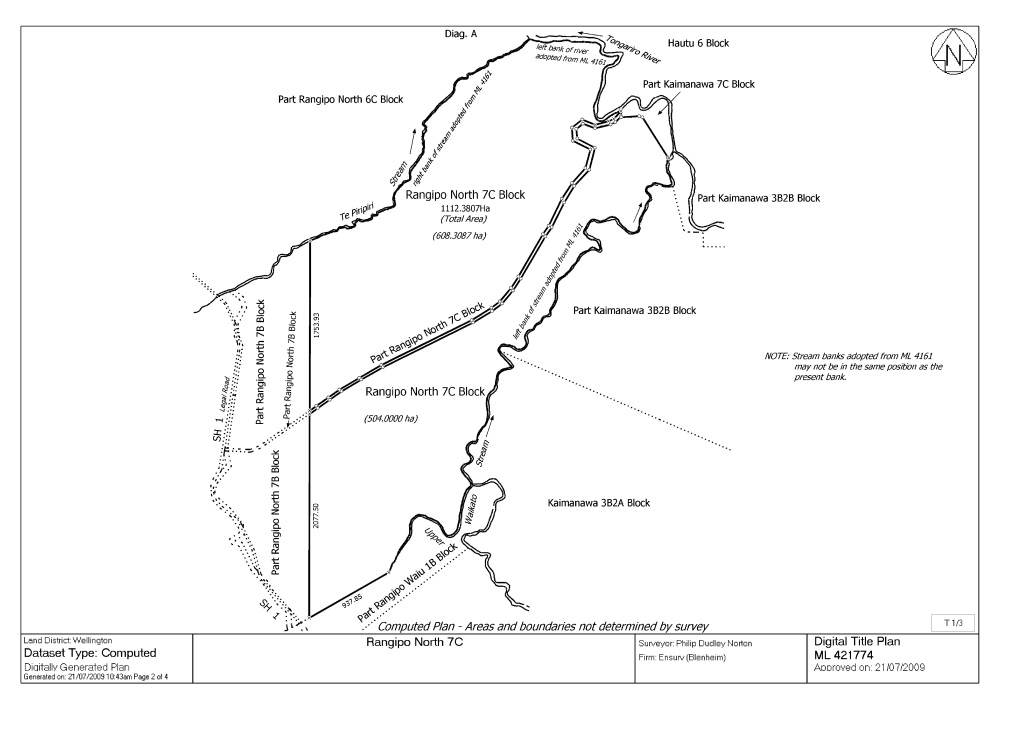
A more recent computed plan of the neighboring Maori land was completed in 2009 - ML 421774. These type of plans were an attempt to work out a more accurate area for blocks of Maori land all over the country. It also shows that the parcels covered by Wapakihi Rd are separate to and not included in the area of the neighboring Maori land. Plan below.....

It will be interesting what TDC say about who is in charge of the land as I suspect it will be them. There is some recent survey work being undertaken to the north on Rangipo Intake Rd by a surveyor which might be in a similar situation. Could be a good person to contact to provide more clarity.
-
03-08-2022, 01:28 PM #341Member

- Join Date
- Nov 2012
- Location
- Palmerston North
- Posts
- 291
Thanks Kickinwings, that helps clarify who doesn't have a legal interest in the road, and also the gazette notice that notes the land was National Park before the acquisition, meaning if the land was no longer needed for the purpose it was taken under the PWA it would be offered back to DOC in the first instance. I am looking forward to the response from TDC now, and whom probably do not wish to be responsible for a road in disrepair.
-
03-08-2022, 01:52 PM #342Member

- Join Date
- Jun 2014
- Location
- CNI
- Posts
- 5,985
Bearing in mind that Genisis still reqykre these roads for monitoring and maintainance of their assets so indicating a possible sharing of road maintainance.
Summer grass
Of stalwart warriors splendid dreams
the aftermath.
Matsuo Basho.
-
03-08-2022, 02:20 PM #343Member

- Join Date
- Sep 2013
- Location
- Taupo
- Posts
- 1,600
TDC initially said it was DOC land when asked via email, and when I checked with the DOC person responsible for boundaries and was told it absolutely wasn't.... TDC decided they would check and get back to us. As yet, nothing.
There is something going on in the background I am beginning to believe, and I would be very unsurprised to find that the "road" has been used as a bargaining chip in settlement negotiations. I would love to be proved wrong, and of course I realise that the Crown can pretty much do as it pleases, but it just isn't adding up.
Something else to think about is that everybody involved in the current talks -FMC, the Iwi, DOC, the settlement negotiators et al are aware of this thread. What I hope the parties who are in elected positions take time to think on is there is an enormous amount of feeling here for the continuation of this particular access point. DOC Turangi and FMC (singing from the same sheet, it appears- and I think there is another story tucked away in there) saying that there are other access points - seriously? I'd like to see someone get to the current road end in less than 8 hours carrying a pack. Essentially it would be a 3 day trip to go for a hunt where the old bridge used to be.
I'm prepared to make this a vote deciding issue for me - in both local and national elections.
-
03-08-2022, 02:40 PM #344
-
03-08-2022, 02:46 PM #345Member

- Join Date
- Sep 2013
- Location
- Taupo
- Posts
- 1,600
Similar Threads
-
Pirongia Forest Park
By Shadowsol in forum HuntingReplies: 4Last Post: 16-03-2020, 05:53 PM -
Tongariro Nat Park (Hauhungatahi) or Kaimanawa Forest Park
By BLABLANZ in forum HuntingReplies: 5Last Post: 31-01-2017, 08:56 PM -
FOUND - DOG - (KAIMANAWA FOREST PARK)
By Barat in forum Hunting DogsReplies: 1Last Post: 06-11-2016, 08:38 AM -
Kaimai forest park
By kawekakid in forum HuntingReplies: 19Last Post: 22-04-2014, 07:19 PM -
Aorangi Forest Park
By D1Hilux in forum HuntingReplies: 2Last Post: 05-11-2013, 07:32 AM
Tags for this Thread
Welcome to NZ Hunting and Shooting Forums! We see you're new here, or arn't logged in. Create an account, and Login for full access including our FREE BUY and SELL section Register NOW!!


 993Likes
 LinkBack URL
 About LinkBacks


 Reply With Quote


Bookmarks