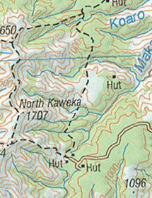
Yup is 1:50000 for sure, remember you don't get the 20 meter contours on 1:250000 scale maps (same as the old paper maps). Contours are 100m @ 1:250000 I believe. The area in the screen shot is basically 1 square km, with contour lines every 20m. Don't mistake a unclear zoom level for map scale. Overall clarity of the Topo50 maps depends on the zoom level incorporated into the maps, the higher the zoom level the greater the file size as you need more tiles for a given area. Basically in Locus once the max available zoom level is reached in a given map you can choose via settings to either lock the zoom or continue zooming where the image is simply enlarged, thus going unclear.
Try the zoom slider on www.nztopomaps (it has the different map scales bracketed on the zoom slider)
1:250000 scale on same area (from PC)
Welcome guest, is this your first visit? Create Account now to join.
Welcome to the NZ Hunting and Shooting Forums.
Search Forums
User Tag List
Results 1 to 15 of 78
Thread: Garmin Monterra GPS
Threaded View
-
17-12-2013, 10:31 AM #11
Last edited by SIKAHUNTER; 17-12-2013 at 10:37 AM.
Similar Threads
-
garmin 62s
By nork1122 in forum Gear and EquipmentReplies: 9Last Post: 15-07-2013, 04:08 PM -
garmin 62s, which sd card?
By foxhound in forum Gear and EquipmentReplies: 0Last Post: 09-03-2013, 06:19 PM
Tags for this Thread
Welcome to NZ Hunting and Shooting Forums! We see you're new here, or arn't logged in. Create an account, and Login for full access including our FREE BUY and SELL section Register NOW!!


 20Likes
 LinkBack URL
 About LinkBacks


 Reply With Quote


Bookmarks