Garmin Monterra GPS Who has one or thinking of getting gone?
8 Reasons To Get Excited - Garmin Monterra GPS - Touratech-USA
Printable View
Garmin Monterra GPS Who has one or thinking of getting gone?
8 Reasons To Get Excited - Garmin Monterra GPS - Touratech-USA
Nice :thumbsup:
What are they worth??? Looks expensive!
800 best I can find in nz cheaper to buy them here then bring them in
Sent from my GT-I9300T using Tapatalk
No radio?
So its basically a $99 smartphone in a case. Just get an otterbox you pussy.
My iphone gets better signal than my rino anyways
800 bucks? screw that! Piss poor screen resolution, crap processor speed. Not worth it in my opinion, the specs of it put it in the sub $100 smart phone bracket, it'd have to have one hell of a good GPS receiver to justify that sort of dosh. For that money you can get a waterproof (IP58) Sony Xperia Z1 that'd do everything far better.
I have a otterbox, an phone is in a lifeproof case to but still better to have GPS an I flicked off my 62scQuote:
Originally Posted by crnkin
All its specs are higher the the 62s/rino so whats not to like with added bonus of having you ballistic program right there to
You get one Abe and I will have a play if you think its any good.
Chris do you use your iphone as a gps? What is the best app?
Adam has got one going to play when he gets back but have convinced myself im getting one anyway lolQuote:
Originally Posted by R93
Trust Adam to have one. He is a true gear freak!:D
Veiwranger is a good one, I sold my gps and just use the phone as wellQuote:
Originally Posted by R93
Maybe a dumb question but does it gets reception without signal? If so how good is it, say under canopy etc?Quote:
Originally Posted by BRADS
Yes but i don't no how it works I'm a simple farmer.Quote:
Originally Posted by R93
I haven't used it in the bush much, other than saying in the very scientific test I did it was working where the 62 wasn't.
Obviously for extended trips a booster battery thingy goes in the pack.
Got one of those. I have downloaded it and will have a play. Ta
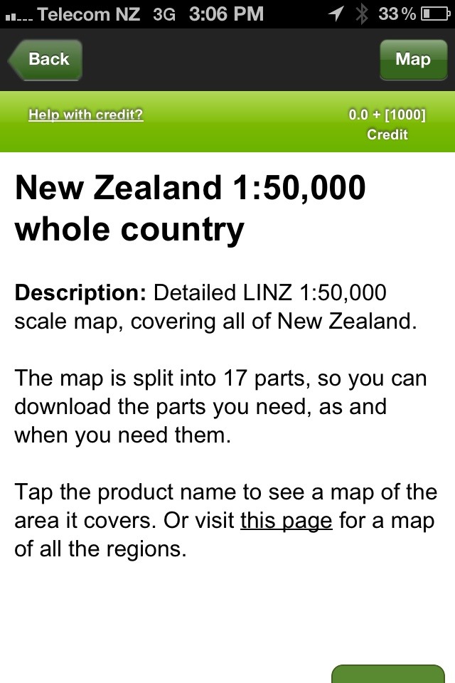
I use an iPhone 4S with Viewranger. Amazing app. I bought the maps for the whole of NZ, all in 1:50,000. I've never had a problem with the GPS, in or out of cell reception. I just turn wifi off and turn 3G off etc when out of reception. Really extends battery life. Did a day trip using Viewranger from 7am until 10pm and battery was still at 70-80%. I've since bought one of those battery recharge packs so I could probably get 7-10 days out of it using it the same way.Quote:
Originally Posted by R93
With the app you can set markers and waypoints and add tons of information to them, as well as loads of other stuff I haven't used yet. I can't really see how a GPS could compete but maybe i'm missing something. Costs about 50 bucks all up for maps for the whole of NZ + the app. You also get a load of credits to buy individual tiles, etc, for other countries if you pay the $17 or whatever for the app instead of the cheaper version. It doesn't seem to have any for Australia yet which is a bit weird...but i'm sure only a matter of time.
And with the phone you have your ballistics apps, conversion apps, a camera, etc, etc. I even have a couple of videos on it showing me how to process deer for when I finally get one...hahaha.
Just noticed it does not have any ozzy maps. I just downloaded it free? Is that a cheap version? I could not find another. Got the whole west coast and otago downloaded so I am sussed. Keen to see how it works at home in the scrub.
Put it down ya pants, if it works in there you'll be good in the worst bush anywhere :PQuote:
Originally Posted by R93
I may be a metro-sexual and could man-scaped Gibo;)Quote:
Originally Posted by Gibo
Your call, I have plenty to say either way :DQuote:
Originally Posted by R93
I feel cornered;)
The Topo 250 you can get free. So those are the 1:250,000 topo maps for the whole of NZ. Still pretty good. There's a big difference with the 1:50,000 ones though. 5 times the detail basically, and you can zoom in heaps.
If you pay for the app you get something like 1,000 credits, which can be used to buy individual tiles of areas. You can then buy individual tiles at 1:50,000 in NZ, or pay the $30-40 for the whole country. I did that and have kept my 1,000 credits for if I ever go overseas or when Aus gets added.
This is what ya want R93
Attachment 17530
That's the one! Awesome maps. The detail without having to carry big unwieldy bits of paper around.
There's always an argument for taking a backup in case your phone breaks or something though.
I downloaded the whole West Coast and Otago for around $6. They are 1:50,000 maps. I downloaded the initial view ranger app for free so was worried it was a cheap version. Looks good so far.
http://img.tapatalk.com/d/13/12/15/3usehyhe.jpg
Screenshot of the map quality. 1:50000
Cheers for the heads up on this Brads.
If it works where I will use it most, I will be stoked.
Sent from my iPhone using Tapatalk
Yup, you're onto it. And see the bar at the bottom? You can zoom in so much on the 1:50,000 maps so as to make that a 200m bar.
I also use Google Earth on my phone and take a few screenshots of the areas i'll be going, so you can even see the terrain, etc. Really handy and again all stored on the marvelous phone!
Still means taking the phone and putting a lot of trust in it. I have back country navigator good for playing wouldn't use it in the bush, I'll let you know how it is soon just got one as well have to keep up with the gear whore lol
Sent from my GT-I9300T using Tapatalk
True, but it's either trust in a GPS or trust in a phone. GPS are more durable and you can get water proof ones, etc, but it's probably pretty close with some of the phone cases around now. I figure as long as you have a good case, and a paper or laminated backup map, and a PLB for when the shit really hits the fan then you're pretty well covered.
Whenever I go with my wife we are just going to keep 1 of the phones turned off in bombproof protection in the pack as well....so we'll have multiple backups.
That's fair call, Modern day hunter I spose you have to stuff up really bad to get lost an need one, only time I use them is coming off the hill tahr hunting on the coast in the dark to avoid getting bluffed all the time...................................where im lazy an keep going down I have Sam an Blair to say left, straight or ok fuck crank that bad boy out here gets nasty as shit :ORLY:
I wouldn't really mind if I didn't have one but like to keep shit down in the back pack an hunt simple the way it should be without a gadget for this gadget for that end up spending more time on technology in the hills then what you do getting back to the basics......................and they don't find you the animals :wtfsmilie:
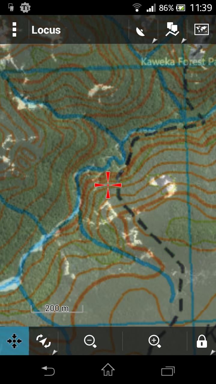
Some other apps to check out: Locus, Back Country Navigator, Maverick. I use Locus Pro myself, has offline maps, topo shading and map overlays (eg overlay Sat map on topo) as well as every other feature you'd need. Developer is responsive too, I requested the NZtopo maps to be added as one of the online options and he added it.Quote:
Originally Posted by R93
Full NZTopo50 maps are available for free (my favorite price) I just use the PC program "Mobile Atlas Creator" to make the offline maps I want - NZTopo50, sat, street or whatever. Copy the file to my phone - easy as.
Attachment 17566
Heres an example of Topo map with Sat overlay (you can adjust the transparancy to suit)
Paper backup is good coz I hate wiping my ass with my phone! :DQuote:
Originally Posted by MattyP
Definitely! I just laminated all my permits and printed maps from New Zealand Topographic Map - NZ Topo Map . Pretty handy, adds bugger all more weight and stops them getting wet/crunched up beyond reading. The downside is you can't wipe anything with them :D.
What I would like more than anything with a GPS/Phone is 1:50,000 maps with DOC approved hunting areas on them. Something to be able to glance at quickly and see, yup i'm in the hunting area. Or, nope, few hundred meters more yet. Ass covering is always good.
I've manually gone through on Viewranger and added the approved hunting areas to a couple of places i'll be visiting. I used the path or trail setting function (can't remember name) to draw them in. Only takes a few minutes using one of the DOC maps for reference, but it won't be perfect so i've erred on the side of caution.
Wow ok those apps are awesome especially tge locus one. Will test out on my next hunt and see what reception is like compared to the rhino... could be a rhino up for sale soon ha ha
Does the Locus one have 1:50,000 maps? The screenshot looks like 1:250,000 at best, which are free on every app i've seen.
I like the sat overlay though!
Just had better look and I think they are 250,000 as you can't zoom very far. Overlay is cool.
Anyone no how to get satellite images on a standard gps like rhino?
That satellite overlay would be the shit!!! I only seem to use a GPS for wallow and track marking or if ever in flat bush somewhere new. But I do appreciate all the extras you can get.:D
I in same boat didn't really need a rino after all . I always assumed you need cell coverage to make it all work . Downloaded that app last night on iPad and iPhone it's pretty cool . Already got otter case for cell and waterproof case for pad . Please no one tell me there is a app that turns cell phone Into UHF :omg:Quote:
Originally Posted by PerazziSC3
Ha ha to right munsey it's quite bad really how far behind a handheld gps is when compared to smart phones, sure they are a bit more rugged but screen resolution and sensitivity is pretty much like a 5 year old phone... I do like the buddy location and message feature on the rhino tho..
Screen resolution and processing speed on my 650 is pretty sweet. Has a 8 megapixel camera, led flash that doubles as a light. I dont know what it is but I just cant rely on my iPhone for this stuff. To fragile?Quote:
Originally Posted by PerazziSC3
I think the smartphone companies should start building purpose built GPS units and drive the tech up and cost down.
What model Gibo? I guess if I was to compare a 62s specs to a smart phone (62s normally $500 ish) I could get everything the 62 has plus a half decent camera and 10x better screen not to mention apps ect in a $80 smart phone....
The selling point for me on the rhino is the radio/message feature...
Now what I would buy would be one of these monterras, with a radio feature and a plb all in one unit. That would be an awesome bit of kit