

 81Likes
 LinkBack URL
 About LinkBacks
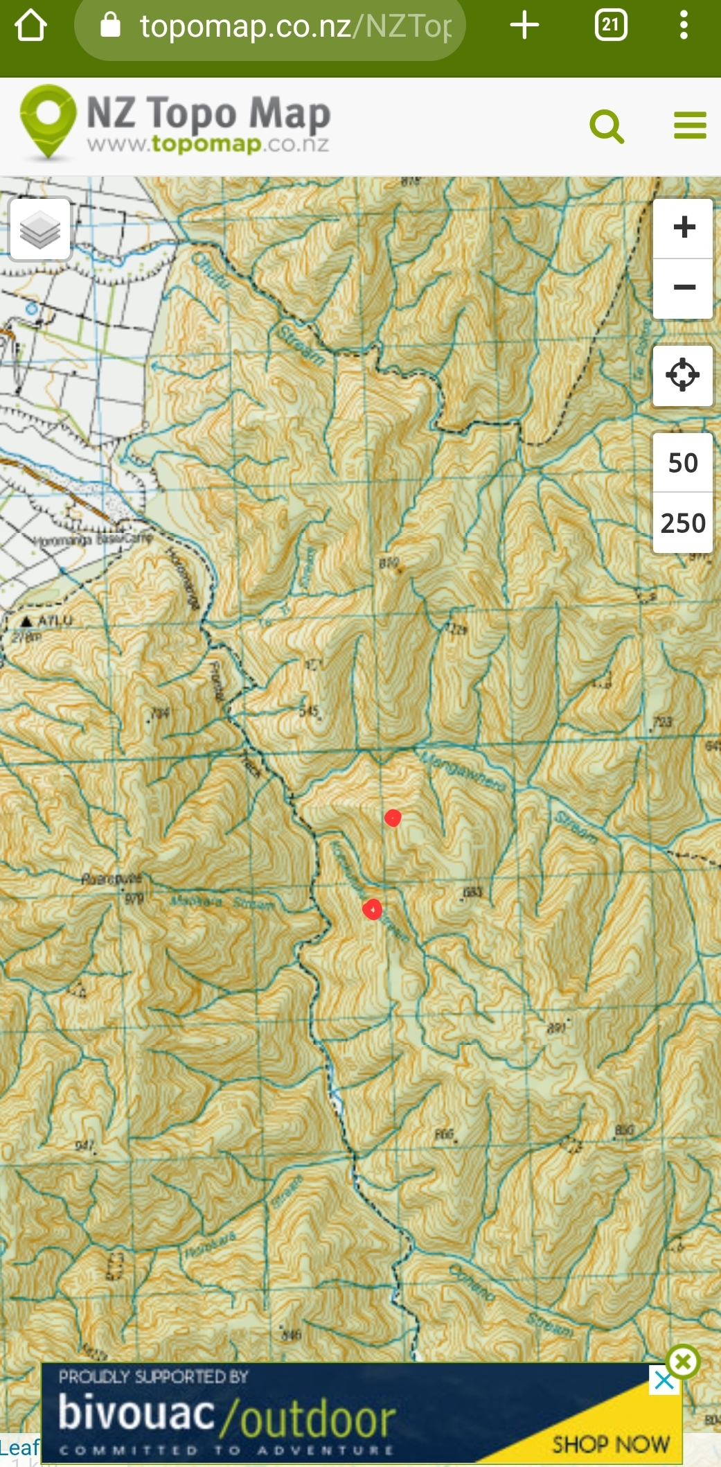
That’d be the one on the left as you walk up river ?Originally Posted by RUMPY

Half way up the ridge ?
Run across it years ago, up there.
Welcome guest, is this your first visit? Create Account now to join.
Welcome to the NZ Hunting and Shooting Forums.
Search Forums


User Tag List
+ Reply to Thread
Results 16 to 30 of 47
-
02-03-2023, 08:12 PM #16Bah, humbug !


- Join Date
- Nov 2013
- Location
- Auckland, until I can escape south....to Southland.
- Posts
- 1,696
He nui to ngaromanga, he iti to putanga.
You depart with mighty boasts, but you come back having done little.
Sounds like a typical hunting trip !
-
-
03-03-2023, 09:53 PM #17Member
- Join Date
- Mar 2012
- Location
- Waikato
- Posts
- 2,175
I wonder if those were actually FRI (Forest research Institute).
There's an exclosure plot right beside the track near Mangamuka hut in the Kaimais. Quite instructive trying to look into it. Putting those up definitely happened before any Health and Safety rules. Untrained town boys fencing with big posts and barbed wire way out in the hills ...
-
03-03-2023, 10:15 PM #18Member
- Join Date
- Mar 2012
- Location
- Waikato
- Posts
- 2,175
Back then, wise words from the boss, personal responsibility for your own safety and a bit of common sense went a long way.
-
04-03-2023, 08:35 AM #19Member
- Join Date
- Jan 2020
- Location
- North Loburn
- Posts
- 667
I think most jokers working for FS would have taken offence in being labelled a townie.Defineately roll your sleeves up,get shit done, rural types.Fencing,c/saws,blasting,bla bla bla to get an exclosure plot,bridge ,etc,constructed all par for the course.And not a clipboard or hi-vis muppet suit in sight. FS had excellent staff training for it's Backcountry tasks.It wasn't FS that built the Cave Creek balls up
Last edited by bluebaiter222; 04-03-2023 at 08:44 AM.
-
04-03-2023, 09:16 PM #20Member
- Join Date
- Jan 2019
- Location
- South Canterbury
- Posts
- 1,649
Yes @Frogfeatures, near one of the red dots or maybe a ridge a bit further back across from midway hut site. Originally Posted by Frogfeatures
 Frogfeatures likes this.
-
07-03-2023, 09:47 PM #21Huntertoo
- Join Date
- Jul 2013
- Location
- Marlborough
- Posts
- 99
I think most jokers working for FS would have taken offence in being labelled a townie.
Thanks Bluebaiter, most of us did.
-
08-04-2023, 09:26 AM #22Member
- Join Date
- Mar 2017
- Location
- HB
- Posts
- 446
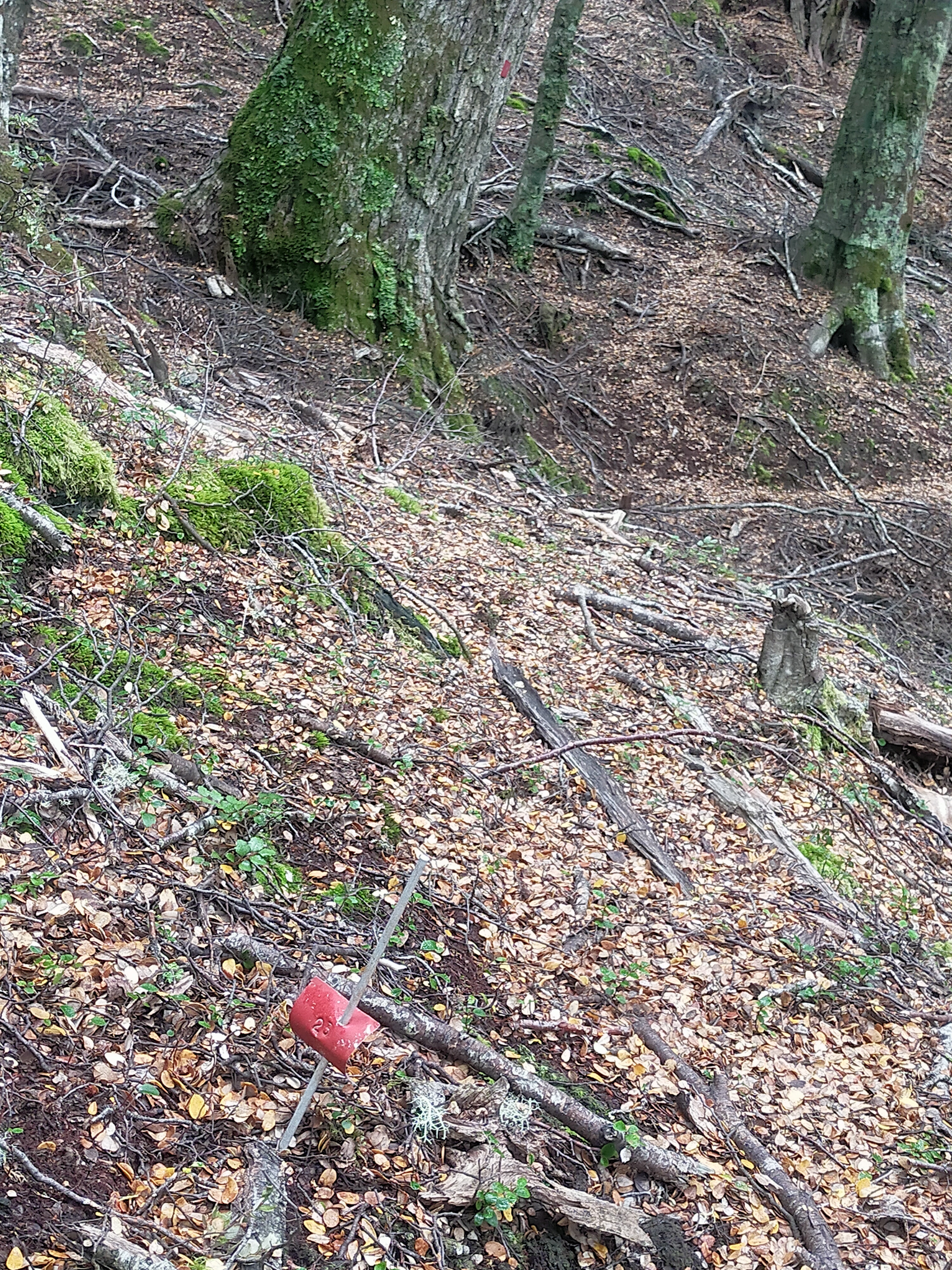
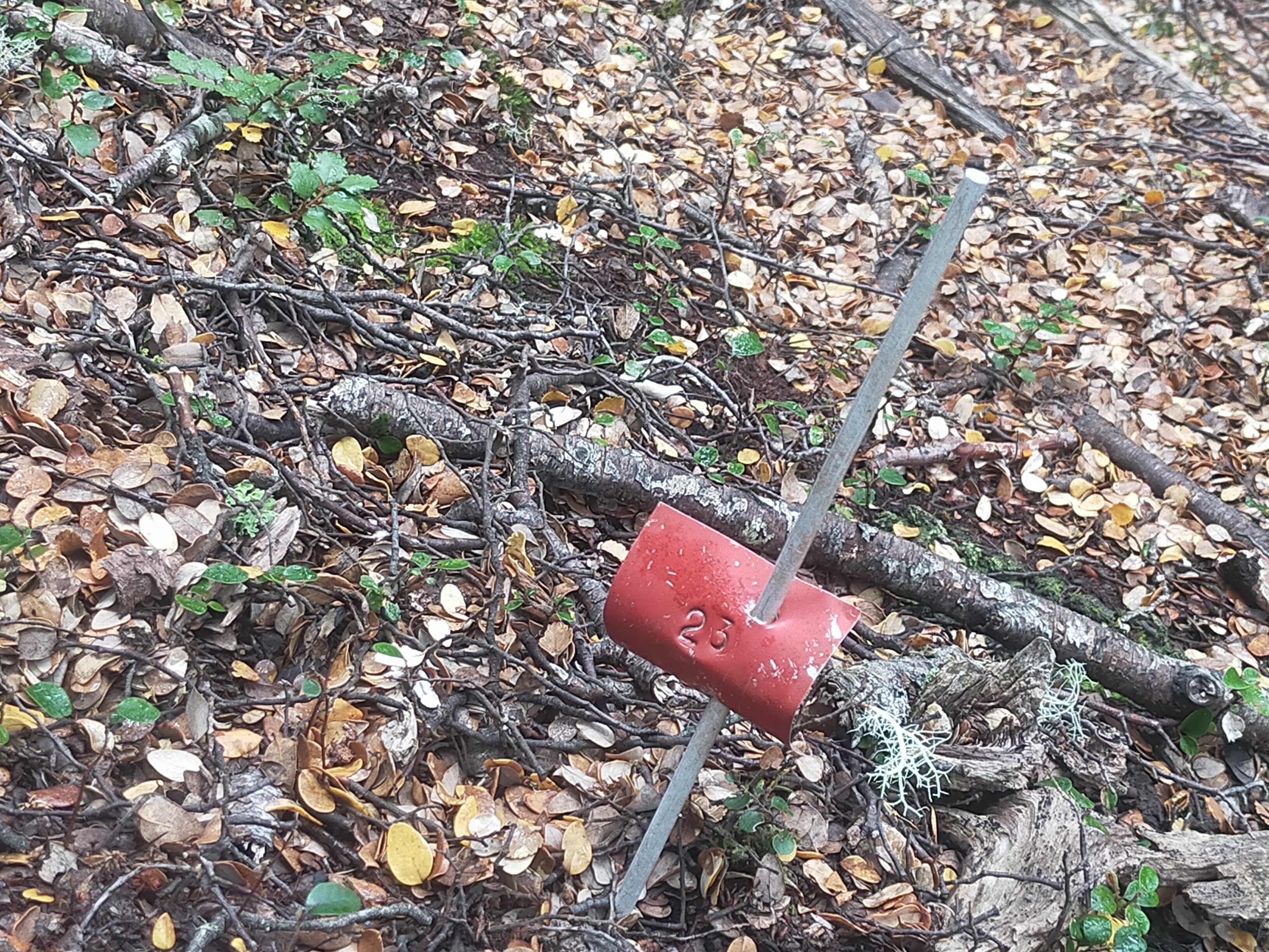
Tier 1 tree tag. Permanent monitoring of a 20x20 site. You get to site, set up tapes to mark the 20x20 based on the orientation of the red permolat being centre of plot, then split 20x20 into 1m2 subplots. Then measure dbh of all trees with a tag, multileaders are over a certain dbh hence they get tagged as well. Also inventory species and seedling counts over the whole plot.
These plots are on a 5 yr rotation, and most were set up in the early 2000s when DoC were looking at measuring stored carbon of the conservation estate. In theory those plots should be every 7km.
Source: I used to do it for a living.
-
08-04-2023, 02:42 PM #23Member
- Join Date
- Mar 2017
- Location
- HB
- Posts
- 446
But as others have said, could be a remnant NZFS veg line as well, depends on the coding on the tag, I don’t think you need much in the way of tech advances to whack tags in a tree.
-
08-04-2023, 05:35 PM #24Member
- Join Date
- Apr 2022
- Location
- New Plymouth
- Posts
- 3,956
no I think Hebe is bang on - that tag pictured is new - no lichen on it - if it was old FS would look old - but great days back then with the old NZFS surveying - loved doing the old shit lines - counting deer turd on set lines to establish population - if ya finished early one got to have an evening hunt in some very remote areas -same as bridge checks - finish early in summer a good 4 hours of evening hunting - I really miss those days - free grub- free helicopter- see some remote NZ - and great mates - what more could one ask for Originally Posted by hebe
-
08-04-2023, 07:37 PM #25Member
- Join Date
- Mar 2017
- Location
- HB
- Posts
- 446
Originally Posted by Barry the hunter
I’m the same @Barry the hunter I still think about those days a lot. I really enjoyed the shit counts but as time went by I started to like the veg stuff just as much. Even leatherwood plots had their charms when you got to watch the sun go down over the hills at night from your tent flap.
-
08-04-2023, 07:54 PM #26Member
- Join Date
- Jun 2014
- Location
- CNI
- Posts
- 5,984
You buggas were lucky. In my time with F&RES we carried two weeks tucker plus gear on our backs. No heli drops They were great times.
Summer grass
Of stalwart warriors splendid dreams
the aftermath.
Matsuo Basho.
-
08-04-2023, 08:32 PM #27Member
- Join Date
- Jul 2020
- Location
- Central North Island
- Posts
- 5,329
Leatherwood plots!!! Originally Posted by hebe
You must be touched in the head
Spent half a day on hands and knees negotiating a very old permolat route completely overgrown by leatherwood just to get at the headwaters of the Pohangina from Howlettsveitnamcam and BRADS like this.
-
30-04-2023, 10:12 PM #28Member
- Join Date
- Jan 2020
- Location
- North Loburn
- Posts
- 667
Recently spotted on a few roar beats in a large Sth Canty Doc valley.50 mtr interval permalat and surprisingly in good operational order 50 yrs old veg grid markers with ally stakes in mid slope silver beech forest.Forest floor bare as a badger honed out by the red menace .vis =150 plus yrds
 [ATTACH]222700
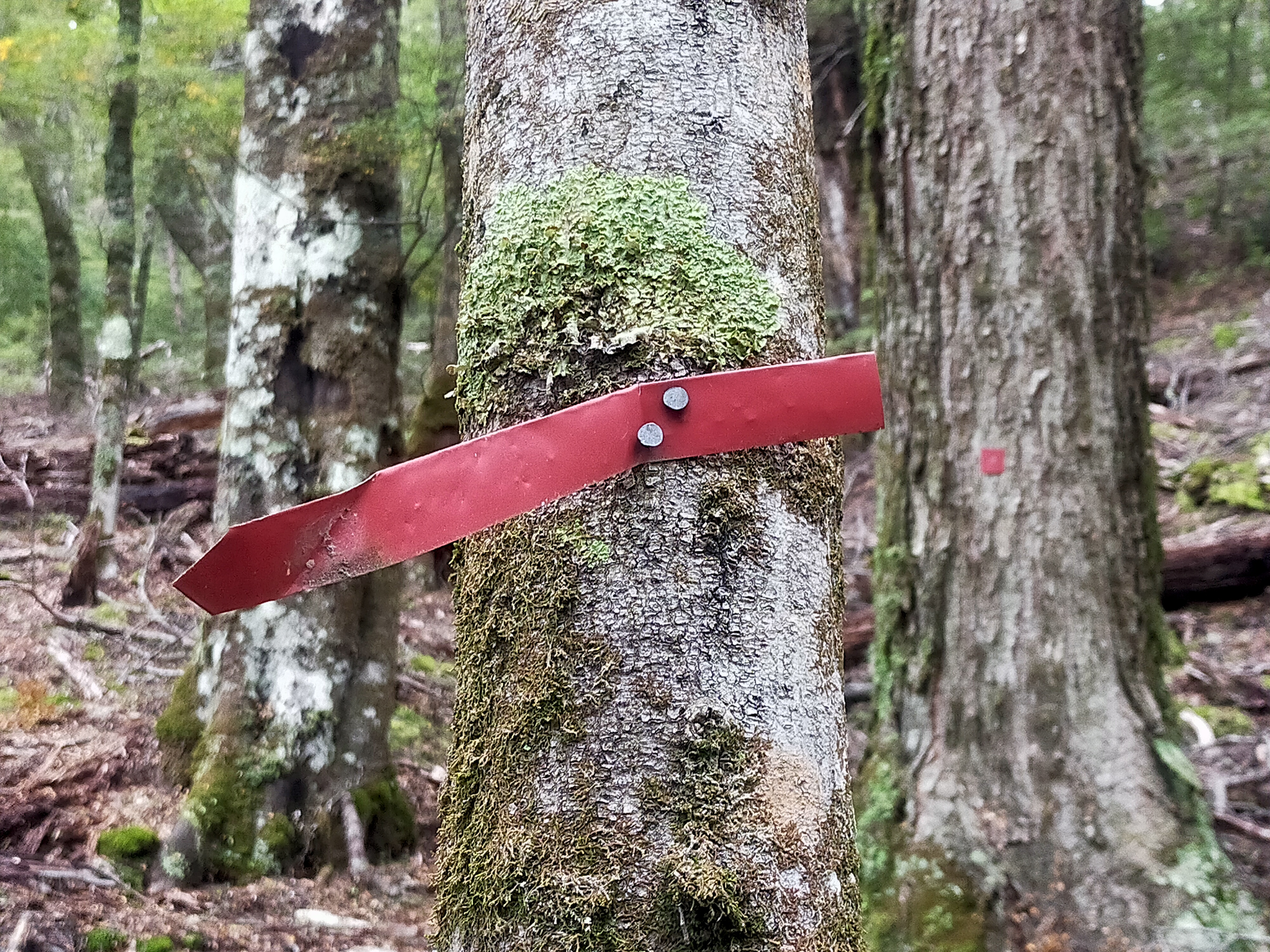 Any amount of runty stags seen with poor head gear.Nothing worth shooting
Steve338 likes this.
Any amount of runty stags seen with poor head gear.Nothing worth shooting
Steve338 likes this.
-
03-05-2023, 02:10 AM #29Member
- Join Date
- Mar 2017
- Location
- HB
- Posts
- 446
They certainly were a bastard to measure. Lots of leaders and hell on the back from being bent forward for two days scrabbling around inside them. I only ever drew one tussock plot atop the Mokai Patea. That was living. Ruapehu to the north, McKinnon to the south, saw a dozen stags moving around the faces from plot while eating lunch and an after work hunt to boot. Originally Posted by XR500
I saw a lot of good country that I’ll never have the time or ability to reach ever again. It was awesome.
-
03-05-2023, 07:22 AM #30Member
- Join Date
- Jan 2020
- Location
- North Loburn
- Posts
- 667
@hebe & I bet your other memory of that stint would be be rarity of that mtn air along with the vistas.Bloody healthy for the brain!Talking of grovelling in leather leaf,while working for FS out of Poh Base,drew a short straw to cut numerous hunting tracks further sth along the range from Takapari Rd on the Ashurst side on all the leading spurs thru the leather leaf down to the likes of Diggers,Opawe,Forks ,etc.Unofficial culling tracks unmarked with the final 200yrds uncut before you
busted thru the leather leaf to hit T Rd @ the top.Any local Manawatu members stumbled onto these tracks? or have they totally reverted?Cut mid 80's.From A Frame sth to Wharite


 Reply With Quote
Similar Threads
-
G'day Fellas
By Spitfire in forum IntroductionsReplies: 11Last Post: 08-06-2019, 11:36 AM -
NZ Forest Service Cook Book
By P38 in forum Resource LibraryReplies: 20Last Post: 20-04-2018, 07:56 PM -
NZ Forest service cook book
By moonhunt in forum HuntingReplies: 7Last Post: 09-11-2013, 09:05 PM
Tags for this Thread
 Posting Permissions
- You may not post new threads
- You may not post replies
- You may not post attachments
- You may not edit your posts
Welcome to NZ Hunting and Shooting Forums! We see you're new here, or arn't logged in. Create an account, and Login for full access including our FREE BUY and SELL section Register NOW!!
All times are GMT +13. The time now is 05:44 PM.

Bookmarks