

 81Likes
 LinkBack URL
 About LinkBacks
Found the odd track up there, but am talking the late 70's.
As an aside, a workmate's dad was the dozer driver who put in Takapari road. Once he had finished he was told by P Nth head office it would be several weeks before they would get a low loader up there to return the dozer to his Dannevirke base.
So he drove it North along the main range for about 2 kms then down the least steep ridge into the west branch of the Tamaki river and out to the road end. There's still the odd bit of evidence that something big went down that ridge...
Welcome guest, is this your first visit? Create Account now to join.
Welcome to the NZ Hunting and Shooting Forums.
Search Forums


User Tag List
+ Reply to Thread
Results 31 to 45 of 47
-
03-05-2023, 09:17 AM #31Member

- Join Date
- Jul 2020
- Location
- Central North Island
- Posts
- 5,339
BRADS likes this.
-
-
03-05-2023, 09:36 AM #32Member
- Join Date
- Jan 2020
- Location
- North Loburn
- Posts
- 668
Hope no lesser spotted weevils were harmed,....the good ol days
-
03-05-2023, 01:53 PM #33By Popular Demand

- Join Date
- Dec 2011
- Location
- The Big H
- Posts
- 9,934
Many of the tier 1 plots are remeasuring older FS NVS plots, so there can be newer tags or permolat at these older plots. Originally Posted by hebe

-
03-05-2023, 02:02 PM #34Member

- Join Date
- Oct 2012
- Location
- Central Hawkes Bay
- Posts
- 9,666
I've seen that and wondered who sacked up and drove down there Originally Posted by XR500
He came out through our farm.
My great grandad drove a bulldozer all the way up the waipawa river 70 odd years ago to make the platform for the current waipawa chalet.
You can still see evidence if your looking carefully
Sent from my SM-S916B using TapatalkMicky Duck and XR500 like this.
-
03-05-2023, 03:17 PM #35Member
- Join Date
- Jul 2020
- Location
- Central North Island
- Posts
- 5,339
Yeah, I used to frequent the Waipawa chalet when that track still looked a bit like a bulldozer track.
Would have been very early 1970's when the Takapari road was bulldozed in.
I worked with the dozer driver's son in the Manawatu gorge, doing all the blasting and straightening up of the sharp corners, back in the mid 1980's.
His old man drove one of those baby poo coloured Range Rovers everywhere, and would often tow one of those new fangled Suzuki 2 stroke 4WD wagons about behind it on an A frame. Had a 'moment' the first time he did it. Coming back from a job in the foothills of the Tararuas he forgot it was on the back, got up to about 90mph on the way back to the pub in Dannevirke...and almost shat himself when he looked in the rear view mirror and saw a 45 horsepower 4wd fair up his arse!!!Micky Duck likes this.
-
03-05-2023, 06:38 PM #36Member
- Join Date
- Mar 2017
- Location
- HB
- Posts
- 447
True. I’m no expert, i only did the one season. Wish id done more. Originally Posted by gimp
-
03-05-2023, 07:29 PM #37Member
- Join Date
- Apr 2022
- Location
- New Plymouth
- Posts
- 3,968
ahhh yes the suzukis - we called them ring dings - bloody good off road - 560 cc 3 cylinder two stroke originally from the Suzuki 560 GT motor bike - now some here may know I understand there was an even smaller motor a 380 cc again from a Suzuki motorcycle in some early model ring dings - but on road fark gutless and the noise ring ding ding ding bout 70 KPH max from memory Originally Posted by XR500
-
03-05-2023, 08:21 PM #38Member

- Join Date
- Oct 2012
- Location
- Waikato
- Posts
- 5,096
I can remember a ring ding. Is that the noise they made if you revved them up and took your foot off the accerator? Classic 2 stroke noise.
The mine I worked in had one dropped off to trial by Suzuki NZ. Mine vehicles were all Landcruisers. (Long since destroyed the Land Rovers and changed over brands.) No one could be bothered to try the Suzuki out, not even the fitters wanted to give it a thrash. So it sat up at admin for days until we (sparkies) grabbed it. Well, it was incredible in the sand but of course very tight passenger wise inside. We kept it for a few days then Suzuki came and retrieved it. IIRC the 2 stroke oil reservoir was inside the passengers glove box.
Rumour was it had last been with the army for trial before we got it, and they had stripped it right down to evaluate it and then reassembled it and returned to Suzuki.XR500 likes this.
-
03-05-2023, 08:29 PM #39Member
- Join Date
- Apr 2022
- Location
- New Plymouth
- Posts
- 3,968
yes the start of a long very successful dynasty now don't get me wrong I love Land Cruisers but for couple of hunters the little suzukis were just great and still are - started with the 380 two stroke then the 560 two stroke both 3 cylinders - then an 850 4 cyl four stroke then a 1000 ccc 4 cyl four stroke then a 1300 four stroke now a 1500 four stroke and coming a 4 door 1500 ccc with electris motors as well - nice of Suzuki to make us such fun - many of the early 560 ,s got modified with better motors Datsun 1200 sss was popular
-
03-05-2023, 08:52 PM #40Member
- Join Date
- Oct 2012
- Location
- Waikato
- Posts
- 5,096
I'm ex Wanagnui, many many moons ago, so commonly saw new Suzukis all lined up at Suzuki NZ way back. Originally Posted by Barry the hunter
The one we had on trial at the mine was astonishing and would go where the Land Cruisers would and then probably some more. I presume it was the 560cc engine? And that was with unsuitable tyres for our conditions.
-
03-05-2023, 09:01 PM #41Member
- Join Date
- Apr 2022
- Location
- New Plymouth
- Posts
- 3,968
WELL Ya wont believe it but there is a ring ding on trade me for sale Originally Posted by zimmer
-
04-05-2023, 03:30 PM #42Member
- Join Date
- Jul 2020
- Location
- Central North Island
- Posts
- 5,339
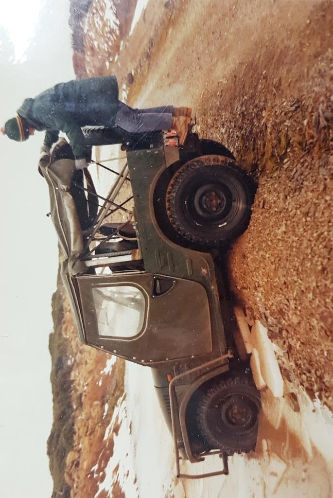
My little Zook stuck in thick ice up on Takapari road. Mid 1980's 560cc engine. Same-ish engine as my road bike of the time Originally Posted by Barry the hunter
-
04-05-2023, 04:19 PM #43Member
- Join Date
- Apr 2022
- Location
- New Plymouth
- Posts
- 3,968
absolute bloody classic what memorys good on ya mate Originally Posted by XR500
-
05-05-2023, 08:17 AM #44Member
- Join Date
- Jan 2020
- Location
- North Loburn
- Posts
- 668
To the discust of the hard core motorheads, the stock std ring dings would frequently podium on the competition off road circuit in production class.got to the point where the V8 guys realized if you can't beat em,join em.That put the value up as a sort after set up and they were quickly snapped up.Along with most Jap vehicles of that time they suffered heavily with cancer and now all have vaporized into IronOxide.Bless the smokey ol Zook!
-
05-05-2023, 08:22 AM #45Member
- Join Date
- Jan 2020
- Location
- North Loburn
- Posts
- 668
3" thick winter ice on Takapari Rd circa '80's.Never to be seen again?Global warming in action.I blaim all the smokey Zooks for the climate emergency


 Reply With Quote
Similar Threads
-
G'day Fellas
By Spitfire in forum IntroductionsReplies: 11Last Post: 08-06-2019, 11:36 AM -
NZ Forest Service Cook Book
By P38 in forum Resource LibraryReplies: 20Last Post: 20-04-2018, 07:56 PM -
NZ Forest service cook book
By moonhunt in forum HuntingReplies: 7Last Post: 09-11-2013, 09:05 PM
Tags for this Thread
 Posting Permissions
- You may not post new threads
- You may not post replies
- You may not post attachments
- You may not edit your posts
Welcome to NZ Hunting and Shooting Forums! We see you're new here, or arn't logged in. Create an account, and Login for full access including our FREE BUY and SELL section Register NOW!!
All times are GMT +13. The time now is 02:50 AM.


Bookmarks