Possible paper road closure. Don't know this track personally but sure some of you will.
https://i.stuff.co.nz/national/30059...nkles#comments
Printable View
Possible paper road closure. Don't know this track personally but sure some of you will.
https://i.stuff.co.nz/national/30059...nkles#comments
Sounds more like it's tidying up access to me. As long as access is maintained I can't see this being a problem
I hunted there a bit when I was at Massey. There was a poled route across the farmland (closed during lambing) and a hut on the edge of the bush (now long gone). Access never went near the house.
Any loss of a paper road is bad news people.
I dont inow the area at all but from my veiw.
The only acceptable compromise is remapping the paper road away from his house on a route that could acually become a road in the future.
Agreed VC.
The constant erosion of access to the western Ruahine is eventually going to lead to more poaching as the access gets cut off. So much access has been lost in recent times.
The big deal here though is it's being driven from local council and the cocky isn't too worried. Yep he wouldn't mind the road moving away from his house, who wouldn't, but who's going to pay? Not the council, they don't want to pay for the grader to go up there x times a year. THATS what the real issue is.
Sent from my SM-G990E using Tapatalk
Agree with your sentiment VC. Perhaps we should all put in submissions to the Council, if someone puts up the detailsQuote:
Originally Posted by veitnamcam
Access to public land and public roads is being cut off all over the country! ....its an epidemic!Quote:
Originally Posted by Reindeer
5th June cut off.
Once the road stoppage is enshrined in private property rights it's game over.
https://www.mdc.govt.nz/news/2022/ro...-of-opawe-road
Sent from my SM-G990E using Tapatalk
He bought the farm knowing full well that it was split in two by being both sides of a road HE DID NOT OWN.
The link Reindeer has provided has an Email address we should all respond to. Its in my old stomping ground.
One farm owner vs tens thousands of potential users of the paper road and public land at the end. Remember those tax payers are the real owners of the paper road and public conservation estate. The council needs to be put back in their box.
Its pissing down here, so no work outside for me. So will spend some time on the phone letting the council know what their real duty is. Then some Emails...
Link states Thurs June 9Quote:
Originally Posted by Reindeer
I am happy to submit even though I will likely never use the road. I hate this sort of crap and it eats at my principals.Quote:
Originally Posted by XR500
Q) If the legal road is shifted to another part of the property, is there a location with terrain suitable for the road to be formed to allow unfettered vehicle access to the Conservation boundary ?. The location would need to be no greater distance than the road takes now.
My bad, should have had my specs on.Quote:
Originally Posted by Moa Hunter
Sent from my SM-G990E using Tapatalk
Submitted.
Pull your head in buddy nowhere does it state in the article that this is anything to do with Joe Public vs the farmer it's an initiative started by the council not the farmerQuote:
Originally Posted by XR500
.....Does it say that in the article? Given DOC's mishandling of relationships with landowners adjacent to the Ruahine Forest Park, please forgive me if I take a dim view of ANY council or DOC relationship with a landowner... Access to the western side of the Ruahine range in particular has been mismanaged in the past, and it wouldn't surprise me at all to see that there has been a misrepresentation in the media about why access has become a media reportable issue...Quote:
Originally Posted by Ryan_Songhurst
For what it's worth - I'm hoping this can be resolved; I like my access to the Ruahines, and if a bunch of arseholes piss off landowners and change access permissions then I'm going to be annoyed.
If there's anything I can do to reassure a landowner, or ensure a privilege is not abused then I am all for it!!!!
Ease up.Quote:
Originally Posted by Ryan_Songhurst
As I indicated previously, in the 1970's and 80's this was my stomping ground. It has never been plain sailing accessing that part of the Ruahines.
Councils do not pick unformed legal roads at random and go through the convoluted process of Stopping them. There is always a motivating factor. And the motivating factor is NOT maintaining public access along an unformed legal road. Any reduction in the legal status of that road is a reduction in the Public's ability to access Public land at the end of the public road. Period.
If its a 'shitheads stuffing things up for everyone' issue, then involve the law. Do not remove unformed legal roads just to make things easy to manage compliance with the law.
What had any of that got to do with the farmer? Your earlier post seems like a pretty clear beat up on the farmer as having instigated all thisQuote:
Originally Posted by XR500
......So its not the farmer???????
Here's a 2009 article.........
https://www.stuff.co.nz/manawatu-sta...-row-escalates
From my prior experience with similar situations of the closure of an unformed public road, I can say that the process is initiated by the landowner first meeting with the council and then making a formal application to them. It is a relatively simple process of gazetting the proposal in the local papers and if there are no objections following this, then the road is annulled gone fineto.Quote:
Originally Posted by Ryan_Songhurst
So in this case it is without doubt that the landowner has made the application to the council and not the other way around
I had the privilege of having access to this property for 35 years prior to moving to Tauranga in 1999 , there was always no access during lambing and we where always welcomed back when lambing was finished .
And some wonder why a.......Quote:
Originally Posted by Ryan_Songhurst
Hunters are becoming so lazy theres a poled route whats the difference.
Imagine a paper road going straight past ya house with your wife and young family home alone while all sorts of meatheads go back and forwards all hours of the day.
I understand what XR500 is saying but hunters have changed a lot from the 70s and 80s definitely for the worse.
Sent from my SM-S906E using Tapatalk
I understand both sides of the argument. But a road is a road is a road. Some are formed, some are unformed. Those roads were surveyed in somewhere between 1880 and 1910. All subsequent land Titles will have had those roads shown as cadastral information on the deposited survey plan. Consecutive owners will have built their dwellings alongside those public roads, either in full knowledge that there is a surveyed road there, or in ignorance. Either way if dickheads walking along an unformed legal road past your home are an issue, its the exact same issue as dickheads walking along a formed legal road past your home. They break the law? call the cops.
As much as people may believe access is a privilege in this instance, its not. Along a formed or unformed legal road It is a right. Plain and simple.
Veer off the unformed legal road, and you are trespassing. plain and simple. Trespassers on your land? Call the cops.
In legal circumstances such as this, where are people happy for their line to be drawn? Unhappy with the law, so have changes made to suit yourself? Or act within the law and accept that the Police are hopeless/under resourced/not interested/whatever.
Anything less than the status quo, or a realignment of the ULR is a cop out, and one small step to losing your right of access to Public land.
Over the last couple of years it would appear that there's plenty quite happy to lose their rights...
I can understand your sentiment Brad's but it becomes part of the thin end of the wedge. This has happened time and again in western side. First it's the vehicular access then the poles routes are gone.
Unlike the Easten side access is getting harder and harder. DoC has cocked it up in a few occasions, kawhatau was colossal screw up.
The farmers comments below.
"This is not the only access to the Ruahine National Park. There is easy access in other areas, up and down the park on both the Manawatu and Hawke's Bay sides," he said.
It's not the only access, until it is!
The eastern side is blessed with lots of great access. So was the western side, when I was a teen, that's near 20yrs ago.
Problem is once opawae is gone how long before titrangi rd, petersons and Renfrew rd?
And I can say for sure the cocky on Renfrew rd would love to shut the gate. Takapari is another problem child.
There is fault on both sides.
But because you are a landowner you don't have an arbitrary right to say no to access.
Sent from my SM-G990E using Tapatalk
Anyone else actually made a submission yet?
The only way access to our backcountry will be maintained is by fighting its erosion by politicians at every chance we get.
Yes
Sent from my SM-G990E using Tapatalk
Yes
Yes
As I wrote in an earlier post I will gladly make a submission, but I need some help from those who know the area if there is a viable alternate route for the road to be relocated to ? I dont want to make a submission that does not propose a viable solution.Quote:
Originally Posted by veitnamcam
Where is the exact location so that I can look at it on Wams ?
Hope this helps https://uploads.tapatalk-cdn.com/202...c2d0d55d0b.jpg
Sent from my SM-G990E using Tapatalk
You are right with this "Imagine a paper road going straight past ya house with your wife and young family home alone while all sorts of meatheads go back and forwards all hours of the day." And we dont have to imagine it, for that is reality for tens of thousands of city dwelling NZ'ers - Crims going past casing areas for houses they can burgle etc.Quote:
Originally Posted by BRADS
If the cocky doesnt like living like the majority of the country that is tough. They can always go halves with the council and fence the roadway, which would be the sensible option.
On our old farm an unformed road went across the centre of a paddock beside the house so we just formed a vehicle access around the boundary and there were no issues.
So having had a look at the maps put up by Tahr and Reindeer the proposal to shift the access and close a section of the road looks sensible to me. I am sure that many submissions will support 'shifting' / adjusting the boundary of one section of the road if a new sensible section of road replaces it and not just an easement
If that how you read my response Ryan was correct about you....Quote:
Originally Posted by Moa Hunter
Sent from my SM-S906E using Tapatalk
Yeah sorry I disagreeQuote:
Originally Posted by Reindeer
I understand the eastern side is a different to the western side
But I don't agree with being the thin end of the wedge about access
Farmers over here are still freely giving up land for access,
Retiring land for parking of cars to make access easier.
Don't lump us all in the same boat.
Sent from my SM-S906E using Tapatalk
If you want to introduce personal slights into the discussion, thats fine wont hurt my feelings, maybe hopefully there will be a day when your eyes can see with some maturity and balance. It matters not whether its a farmer a developer or American billionaire whos applied to close part of a public road the principal is the same 'public land becoming private land at the stroke of a pen' Now Brads, some condescending maths for you a roadway is surveyed 20mtrs wide which means every 500 mtrs of road is one hectare. How much is say two hectares of land in the area of the track worth ?Quote:
Originally Posted by BRADS
Here's my submission, if that helps anybody else. This access stuff must be protected (and access improved) where ever possible. Everyone needs to be vigilant and stand up for it constantly if we're to keep access to public land - once it's gone it's gone.
You can find an email address to send similar to my submission if you want, on the council link here. Don't be a bystander and watch our access disappear.Quote:
I'm writing to submit my strong opposition to the removal of the paper road as mentioned here:
https://www.mdc.govt.nz/news/2022/ro...-of-opawe-road
Paper roads have protections and access rights that cannot be changed. An easement or pathway is not the same thing. I particularly consider hunters here, as firearms can be problematic - but with a road, they are legal. By all means, move the paper road to follow the better route, but don't have it as an easement or pathway, but as a paper road - like for like.
Our backcountry is already hard enough to get to due to poor foresight from planners of the past - particularly the Ruahine ranges. To remove any kind of level of access permissions or right for the future is incredibly short-sighted for all backcountry recreation and conservation users. Surely a moved paper road with the same legal protections as the current, to follow a more sensible curve will satisfy both parties. As a country it boggles my mind that we continue to facilitate single landowners limiting (in any way, however small) the other 5 million of us's access to our forest ranges.
I hope the council makes the right call for the future.
https://www.mdc.govt.nz/news/2022/ro...-of-opawe-road
Love it!Quote:
Originally Posted by LarryB
Mine followed simmilar lines but was less articulate.
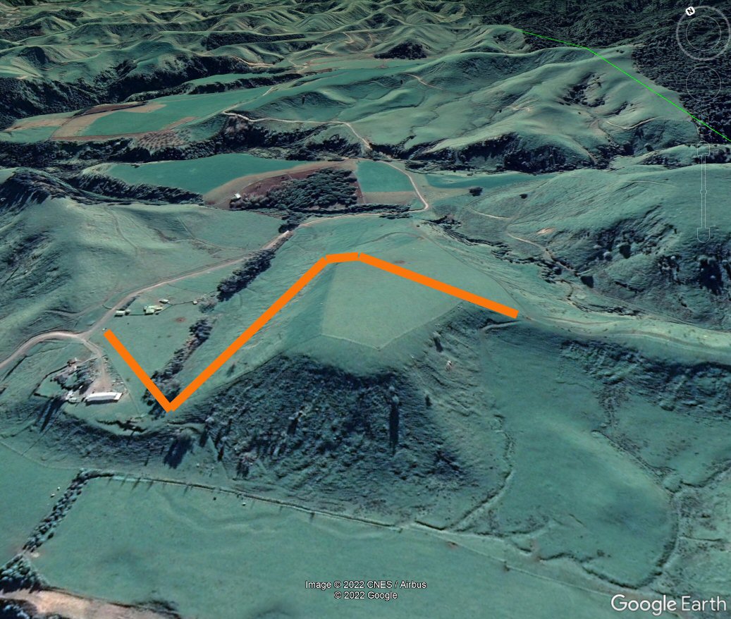
Here is a cut & paste from Google Earth that gives a better idea of where the existing road cuts up to attain the ridgeline.
An alternative to reach the upper paddock and rejoin the remaining road and current walking route (purple) could perhaps - judging from the apparent gradient looking from the other direction - follow the line of one of the existing farm tracks that have their point of access from further up Opawe road?
Attachment 198172
Attachment 198173
I live in Ashhurst (15 minutes from Opawe Road) so I've been following this with interest.
I ended up contacting the council because I had some questions after reading the Stuff article and the Manawatu Council website. The council were good to deal with.
The important thing is that the proposed easement will mean access will continue. I think the current landowner's motives seem pretty genuine in wanting to make the route clear and avoid people wandering over his property.
My only concern is whether an "easement in gross" has the same protections from being closed by subsequent landowners as a "paper road". I've googled it but can't get my head around it. Does anyone actually know how these things work? I'd like to know before I make a submission.
I have to say I've always found landowners around here pretty approachable. In the last month I've asked two farmers for permission to go across their land for fishing and they were both really friendly and had no problems with it. I've had a few refusals when it came to shooting/hunting but usually for a good reason but a lot of the time the farmers were pretty keen hunters themselves and were OK with it or suggested who else to ask.
I havent submitted yet either but have a draft sketched out. Without knowing the exact terms of the proposed easement / right of way I am uncomfortable with the unformed road being stopped. I do however support the Council and landowner desire to 'tidy up' the current impractical legal road access. Two links that might help:https://www.linz.govt.nz/kb/520 https://www.gallawaycookallan.co.nz/...r-right-of-wayQuote:
Originally Posted by cbfb
From the second link I can see that if a future landowner causes grief for hunters using the fenced easement by for example pugging it up with cattle or blocking it, the matter would end up in court - if the Council would pay, whereas a legal road has much greater protection and remedy