if you go into WAMS maps and select aerial photos clearings like that show up really well - a tip with WAMS maps go into the menus and take off any info you dont need such as railway lines roads any layer you just dont need - it means the map system works faster instead of searching all of NZ - once you get used to it you can identify feed areas such as mahoe faces slips open creek beds give it a go you will be surprised - I use it for any new area
Welcome guest, is this your first visit? Create Account now to join.
Welcome to the NZ Hunting and Shooting Forums.
Search Forums
User Tag List
+ Reply to Thread
Results 46 to 56 of 56
Thread: Pureora 1080d yet ?
-
25-09-2024, 01:12 PM #46Member

- Join Date
- Apr 2022
- Location
- New Plymouth
- Posts
- 3,852
-
-
25-09-2024, 08:19 PM #47Member

- Join Date
- Sep 2020
- Location
- Hamilton
- Posts
- 61
-
25-09-2024, 08:39 PM #48

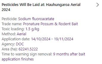
As Kune said, moved to mid October. It's been getting pushed back for several months, unfortunately now it looks like its going to really stuff up the prospects for spring hunting in there.
-
26-09-2024, 08:33 AM #49Member

- Join Date
- Sep 2020
- Location
- Hamilton
- Posts
- 61
It really is a pain itís been pushed back so far. Probably be a good six months from the drop that Iíll be happy to take the dog in again.
-
26-09-2024, 09:13 AM #50Member

- Join Date
- Dec 2021
- Location
- Tauranga
- Posts
- 5,877
Probably won't happen then in there, weather patterns at that time seem to usually involve rain.
-
26-09-2024, 09:42 AM #51
-
26-09-2024, 10:13 AM #52Member

- Join Date
- Dec 2021
- Location
- Tauranga
- Posts
- 5,877
You'd think that the date being pushed back so far would be counter-productive for their aims at supporting the reduction of deer numbers - it will stuff up the 'roar' hunt in terms of hunters willing to go in. The numbers of parties getting dropped in by air taxi will be down I'd think so those outfits will be pissed off too. My understanding is the initial whack to deer numbers is in the first month, then the baits are no longer palatable for deer and with the higher than usual numbers everywhere around that area the migration back in will probably make good any losses in the first few months. Followed by a roar period without the usual hunting pressure - things will be good for the deer I would think and not so for the forest???
-
26-09-2024, 10:50 AM #53Member

- Join Date
- Sep 2013
- Location
- Taupo
- Posts
- 1,591
Give them a call.
07 878 1080
-
28-09-2024, 08:14 AM #54
i dont think DOC has any regard for hunters feelings ..... from memory the last time they did a drop like this in spring was around 10 years ago so long overdue in their eyes i was in there a week after the drop green shit everywhere . the birdlife had either gone or died or just shut the fuck up saw more deer in that weekend than on any other time down there. and saw plenty of rats .... we treated the weekend as a training weekend (only shoot a deer if it looked sick and give the healthy ones a crack at surviving) a DOC ranger(a few fingers short of the handfull ) was still harvesting deer for himself during the "do not harvest" period afterwards ......do as i say not as i do....
anyhoo point is it can still be a good time to be in there , whether you harvest or not (probably just dont take a dog )
-
28-09-2024, 08:23 AM #55Member

- Join Date
- Apr 2012
- Location
- Kingcountry
- Posts
- 5,038
-
28-09-2024, 02:46 PM #56Member

- Join Date
- Jun 2014
- Location
- CNI
- Posts
- 5,978
The HSNO regs forbid delibdrate targeting of large mammals like deer by use of 1080 poison. This was established during the ERMA (now EPA) review in 2008.
Summer grass
Of stalwart warriors splendid dreams
the aftermath.
Matsuo Basho.
Similar Threads
-
Pureora
By mohawk in forum HuntingReplies: 15Last Post: 29-11-2015, 05:49 PM -
Pureora
By seagers in forum HuntingReplies: 7Last Post: 29-07-2015, 08:15 PM -
pureora
By Htown in forum HuntingReplies: 11Last Post: 16-09-2014, 09:36 PM -
Pureora
By Htown in forum Varminting and Small Game HuntingReplies: 1Last Post: 31-07-2014, 07:32 PM -
Pureora
By BushHunter in forum HuntingReplies: 37Last Post: 12-09-2013, 07:41 PM
Tags for this Thread
Welcome to NZ Hunting and Shooting Forums! We see you're new here, or arn't logged in. Create an account, and Login for full access including our FREE BUY and SELL section Register NOW!!


 21Likes
 LinkBack URL
 About LinkBacks


 Reply With Quote


Bookmarks