Welcome guest, is this your first visit? Create Account now to join.
  • Login:

Welcome to the NZ Hunting and Shooting Forums.

If this is your first visit, be sure to check out the FAQ by clicking the link above. You may have to register before you can post: click the register link above to proceed.

Alpine Night Vision NZ


User Tag List

+ Reply to Thread
Page 1 of 2 12 LastLast
Results 1 to 15 of 17
Like Tree12Likes

Thread: What topo app for iphone

  1. #1
    Member
    Join Date
    Apr 2019
    Location
    Tauranga
    Posts
    741

    What topo app for iphone

    As described, ideally wanting doc hunting area overlay as well as satellite imagery. Tried pocket maps but it’s playing up big time.

    Cheers

  2. #2
    Member Micky Duck's Avatar
    Join Date
    Apr 2015
    Location
    Geraldine
    Posts
    24,797
    NZtoppo 50
    stug, MB, Allizdog and 1 others like this.
    75/15/10 black powder matters

  3. #3
    Member
    Join Date
    Jan 2019
    Location
    South Canterbury
    Posts
    1,522
    Make sure you get the right one. Costs 6 bucks. A lot of people on a tramping forum I'm on get some different weird ones that you have to individually download each area you want. This one is all available offline. IT'S GOOD.
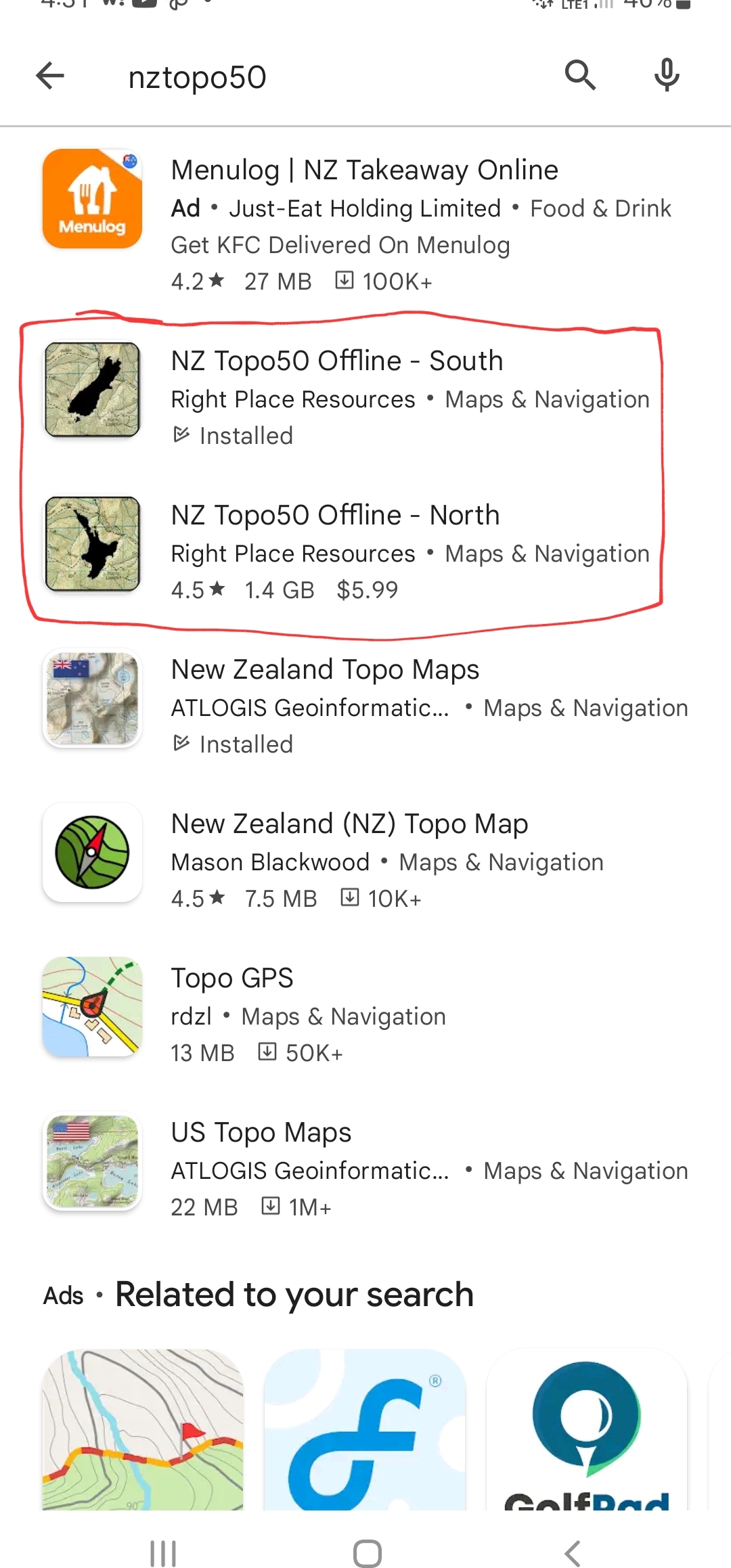
    Name:  Screenshot_20221030-163222_Google Play Store.jpg
Views: 309
Size:  582.6 KB
    stug, Micky Duck, MB and 1 others like this.

  4. #4
    Member
    Join Date
    Apr 2019
    Location
    Tauranga
    Posts
    741
    Cheers guys, got it loaded. Exactly what I was after!

  5. #5
    Member
    Join Date
    Sep 2019
    Location
    Rural TeAwamutu
    Posts
    1,836
    If using a iPhone iHike is great. Pity they don't make a android one..

    Sent from my SM-T225 using Tapatalk
    Low box and MB like this.

  6. #6
    Member Bobba's Avatar
    Join Date
    May 2018
    Location
    Ngaruawahia
    Posts
    1,299
    Quote Originally Posted by Bushline View Post
    Cheers guys, got it loaded. Exactly what I was after!
    Yep brilliant app. When you find that primo spot, track or nice wallow you can mark it, take a photo and notes and save it in the app.

  7. #7
    MB
    MB is offline
    Member MB's Avatar
    Join Date
    Jan 2016
    Location
    Deerless North
    Posts
    4,725
    Quote Originally Posted by tiroahunta View Post
    If using a iPhone iHike is great. Pity they don't make a android one..
    It is. iHike-GPS is what I use for navigation (i.e. most of the time) with NZ Topo50 for satellite and DOC overlays.

  8. #8
    Member
    Join Date
    Apr 2019
    Location
    Tauranga
    Posts
    741
    I’ve had ihike before and the nz Topo50 seems a lot more user friendly?

  9. #9
    Caretaker stug's Avatar
    Join Date
    May 2012
    Location
    Rolleston, Canterbury
    Posts
    5,058
    The only issue I have with Topo50 is the free rotate function doesn’t work. Pain in the arse when trying to navigate to a waypoint.

  10. #10
    MB
    MB is offline
    Member MB's Avatar
    Join Date
    Jan 2016
    Location
    Deerless North
    Posts
    4,725
    Quote Originally Posted by Bushline View Post
    I’ve had ihike before and the nz Topo50 seems a lot more user friendly?
    I guess it comes down to personal preference. I don't like waypoint management on NZ Topo50, but will give it another go at some point.

  11. #11
    Member
    Join Date
    Feb 2016
    Location
    Wellington/Porirua
    Posts
    399
    Quote Originally Posted by stug View Post
    The only issue I have with Topo50 is the free rotate function doesn’t work. Pain in the arse when trying to navigate to a waypoint.
    That function works fine for me.

  12. #12
    Member Happy Jack's Avatar
    Join Date
    Jan 2020
    Location
    Nelson/Tasman
    Posts
    3,899
    My only gripe with topo50 is you can't delete or hide built in waypoints which makes finding your own ones a bit of a pain

  13. #13
    Member
    Join Date
    Feb 2016
    Location
    Marlborough
    Posts
    1,038
    Quote Originally Posted by Happy Jack View Post
    My only gripe with topo50 is you can't delete or hide built in waypoints which makes finding your own ones a bit of a pain
    Go into search then tap selection in bottom left corner to use your own selection of waypoints.

  14. #14
    Member Nathan F's Avatar
    Join Date
    Dec 2011
    Location
    Deep South
    Posts
    2,302
    Maptoaster is the way to go

  15. #15
    Member Happy Jack's Avatar
    Join Date
    Jan 2020
    Location
    Nelson/Tasman
    Posts
    3,899
    Quote Originally Posted by Nathan F View Post
    Maptoaster is the way to go
    Used that on a friends PC but prefer the memory map I have on my pc and topo50 on the android phone


Similar Threads

  1. Topo app
    By Cowboy in forum Firearms, Optics and Accessories
    Replies: 10
    Last Post: 07-03-2020, 07:30 AM
  2. Topo GPS
    By MB in forum Gear and Equipment
    Replies: 0
    Last Post: 04-07-2017, 02:47 PM
  3. Sat nav with topo
    By Pengy in forum Gear and Equipment
    Replies: 0
    Last Post: 10-11-2013, 11:41 AM
  4. GPS Topo Map
    By lost in forum Gear and Equipment
    Replies: 21
    Last Post: 27-07-2013, 08:06 PM

Tags for this Thread

Bookmarks

Posting Permissions

  • You may not post new threads
  • You may not post replies
  • You may not post attachments
  • You may not edit your posts
Welcome to NZ Hunting and Shooting Forums! We see you're new here, or arn't logged in. Create an account, and Login for full access including our FREE BUY and SELL section Register NOW!!